



Reportage
After the deluge


An Independent Newsweekly







Reportage
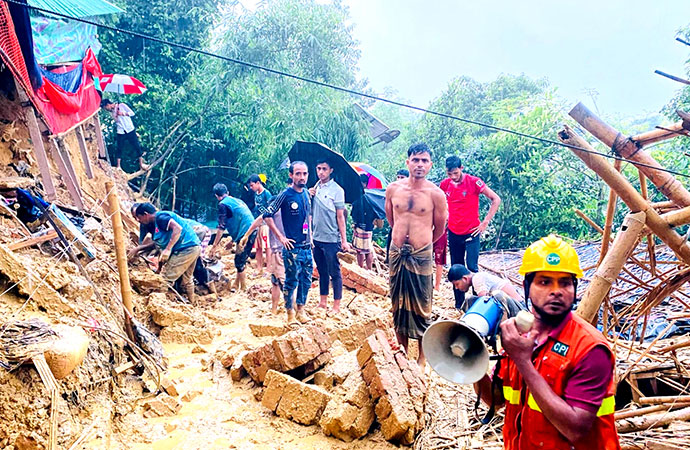
Rescuers work at the site of a landslide at a Rohingya refugee camp in Cox's Bazar, Bangladesh, Wednesday, July 8, 2026. Photo: AP/UNB
Starting July 6, multiple landslides claimed the lives of several Rohingya refugees and local residents, including children, in four separate districts of Chattogram, as incessant monsoon rain drenched almost the entire country, flooding cities and villages, disrupting air, rail, road and river transport, triggering landslides and raising fears of floods across several districts.
The downpour, triggered by a monsoon depression, also caused rivers in the Chittagong Hill Tracts to swell by nearly six metres within a day, inundated thousands of homes, disrupted power supply and damaged transport and communication networks. Eleven people, including eight Rohingyas, were killed in different landslides in Cox's Bazar on Monday.
The Chattogram region recorded 394 millimetres of rainfall in the 24 hours till 6:00pm Tuesday (July 7).
Continuous rain inundated more than 50 villages across Cox's Bazar district and flooded low-lying areas in the district town, Teknaf, Kutubdia and Maheshkhali. More than 40 shelters in Rohingya Camp No. 2 also went under water.
District relief and rehabilitation officer Ajader Rahman said eight Rohingyas were killed in landslides at camps 7, 11 and 15 on Monday, while three other people died at Pekua, Lighthouse Para and Daria Nagar.
Floodwaters also stranded about 50,000 people in more than 30 villages in Ukhiya, while another 50,000 people were affected in Chakaria and Matamuhuri. Persistent rain caused severe waterlogging across Chattogram city, submerging roads in Agrabad, Patenga, Chandgaon, Bakalia, Chawkbazar, Badamtali and several other areas, said district relief and rehabilitation officer Mohammad Masudur Rahman.
The latest tragedy occurred on July 8, when a hillside collapsed onto a madrasa inside a Rohingya camp, reportedly killing at least 4 girls and injuring several others as children attended classes.
More than 250 millimetres of rain fell within a 24-hour period, causing landslides, flooding and widespread damage to shelters across the camps. Authorities have warned that heavy rainfall is expected to continue, increasing the risk of further landslides and flash floods in one of the world's most densely populated refugee settlements.
Kabita Bose, Country Director, Plan International Bangladesh said: "We are deeply saddened by the tragic loss of lives and extend our heartfelt condolences to the families who have lost their loved ones."
"The deaths of children in deadly landslides are particularly heartbreaking. Every monsoon season brings heightened risks for Rohingya communities and host communities living on unstable hillsides and in low-lying areas."
Meanwhile, Chattogram witnessed its highest single-day rainfall in 42 years on Wednesday as relentless monsoon showers inundated large parts of the port city, causing severe waterlogging, and bringing normal life to a near standstill.
The Bangladesh Meteorological Department recorded 412.3 millimetres of rainfall in 24 hours till Wednesday morning, the highest daily rainfall in the city since weather records of this kind began 42 years ago, said assistant meteorologist Bashir Ahmed.
He said that the record rainfall combined with hill runoff and high tides in the Karnaphuli River caused widespread waterlogging in the low-lying areas across the city. Heavy rain which began before dawn, submerged roads in many areas, leaving commuters, office-goers, students and pedestrians stranded. Water reached knee to waist height in some areas, severely hampering vehicular movement.
Roads in different parts of the city including Agrabad Access Road, Badamtali, Bakalia, Chandgaon, Mohra, Katalganj, Halishahar, Patenga, Chawkbazar and the port area were inundated.
In several places, roads and drains became indistinguishable, forcing vehicles to move slowly, while small vehicles were unable to operate in some areas. Rainwater also entered numerous homes and business establishments, adding to residents' hardship.
The Met Office said active monsoon conditions are likely to bring heavy to very heavy rainfall over the next few days, raising the risk of prolonged waterlogging and landslides in vulnerable areas. Officials said that the Chattogram City Corporation, with support from the Bangladesh Army, is continuing drainage, canal and sewer cleaning operations in different parts of the city to facilitate the quick discharge of accumulated rainwater.
The district administration has urged residents living in landslide-prone hill areas to remain vigilant and consider moving to safer locations.
Precipitation maxes out
The record rainfall resulting in the deluge in Chattogram in particular, has primarily been caused by active monsoon conditions paired with the powerful influence of a low-pressure system. According to reports from the Bangladesh Meteorological Department, these two dominant atmospheric forces have synchronised to pump relentless precipitation across the country.
This is still pretty early days in the region's south-westerly monsoon season, but it is highly active directly over Bangladesh and tracking strongly across the North Bay of Bengal. It is continuously pulling heavy moisture into the region from the south-west. Coupled with that is a strong, well-marked low-pressure system (previously developing into a deep depression) formed over the Bay of Bengal. Though its centre has gradually drifted over land toward eastern India, it has maintained a steep pressure gradient over the northern Bay. This meteorological gradient generates intense, dense cloud formations and persistent squally weather across Bangladesh's coastal zones and inland divisions.
Three rivers in Feni
Rising water levels in three rivers in Feni fuelled by heavy rainfall and upstream hill runoff from India's Tripura state have heightened fears of flood among thousands of people in riverside areas. Residents of Parshuram, Fulgazi and Chhagalnaiya upazilas spent a sleepless night watching vulnerable embankments, fearing that any breach could inundate their homes as has happened repeatedly in previous years.
According to the Feni District Weather Office, the district recorded 56 mm of rainfall in the 24 hours until 9am on Thursday.
District Weather Officer Mujibur Rahman said rainfall influenced by the active monsoon is likely to continue for the next few days. The situation has been worsened by upstream water flowing down from Tripura.
Data from the BWDB showed that the water level of the Muhuri River at the Parshuram point rose to 10.66 metres at 9am on Thursday from 10.40 metres at midnight, an increase of 0.26 metres within seven hours.
Although the river is still below its danger level of 12.55 metres, officials said the rapid rise in water levels has increased concern among local residents. People living along the Muhuri, Kahua and Silonia rivers said embankment breaches during the monsoon have become a recurring problem, often causing extensive damage to homes, cropland, fish enclosures and livestock.
"We are most afraid during the night. We cannot sleep because we fear the embankment may collapse at any moment and flood our homes," Sahabuddin, a resident of Fulgazi, told UNB.
In response to the growing risk, the district administration has stepped up preparedness.
An emergency meeting of the District Disaster Management Committee was held at the deputy commissioner's conference room on Tuesday to review the situation and prepare response measures.
Deputy Commissioner Monira Haque said water levels in the district's rivers are rising due to heavy rainfall in Tripura and the administration is taking maximum advance preparations to tackle any possible emergency. She said government officials, medical teams and volunteer organisations have been instructed to remain prepared while efforts are underway to clean cyclone shelters and stockpile dry food.
BWDB Executive Engineer Monirul Islam said officials are monitoring river water levels and embankments round the clock and keeping emergency repair teams ready for vulnerable points.
Parliament gets briefed
Incessant rainfall-triggered floods and landslides have so far claimed 30 lives - 19 in Cox's Bazar, five in Chattogram, five in Bandarban and one in Rangamati, Disaster Management and Relief Minister Asadul Habib Dulu told parliament on Thursday.
He said the government is giving the highest priority to ensuring the safety of people affected by floods and landslides in Chattogram and the Chattogram Hill Tracts alongside providing emergency relief assistance.
Delivering his statement under Rule 300 of the Rules of Procedure in the Jatiya Sangsad, the minister said the government is working on a war footing to protect affected people and meet their immediate humanitarian needs.
To accommodate displaced people, the government has opened 1,057 shelters - 41 in Chattogram, 640 in Cox's Bazar, 21 in Rangamati, 135 in Khagrachhari and 220 in Bandarban, he said.
The minister said 8,340 people have taken shelter in Chattogram, while 126 are staying in shelters in Rangamati, 1,755 in Khagrachhari and 2,173 in Bandarban. Dulu said the government initially allocated Tk 1 million in cash under the Gratuitous Relief (GR) programme and 200 metric tonnes of rice to each of the five affected districts on July 7.
To strengthen the ongoing response, additional allocations were approved on Thursday, he added. Chattogram received Tk 2.5 million, Cox's Bazar Tk 2 million, while Rangamati, Khagrachhari and Bandarban each received Tk 1 million, the minister said.
The government also allocated an additional 300 metric tonnes of rice for Chattogram, 250 metric tonnes for Cox's Bazar and 200 metric tonnes each for Rangamati, Khagrachhari and Bandarban. The minister said public announcements through loudspeakers are continuing to encourage residents of vulnerable areas to move to safer locations.
He said shelters have been equipped with safe drinking water, sanitation facilities, baby food and arrangements for three meals a day for displaced people. Dulu also said the Prime Minister's Relief and Welfare Fund has allocated Tk 2 million for each of the affected districts.
"The Prime Minister is closely monitoring the situation and providing necessary directives. More emergency assistance will be allocated if required," he added.
Highlighting the recurring loss of lives from landslides, the minister said the government is prepared to rehabilitate families living on vulnerable hill slopes by constructing houses on khas land and other government land. He urged local lawmakers to actively raise public awareness and support the relocation initiative, expressing hope that coordinated efforts would significantly reduce future casualties from landslides.
Landslides: Not 100% nature
The UN Refugee Agency (UNHCR) said 95 landslides occurred across the Rohingya camps between July 4 to 9. At least 15 Rohingya refugees were killed in the incidents, while 4,307 people were left homeless. A total of 26,119 people were affected in various ways.
UNHCR Representative in Bangladesh Ivo Freijsen said humanitarian agencies, in coordination with the Bangladesh government, were continuing emergency rescue operations, relocating refugees to safer areas and providing food, medical care, shelter and other emergency assistance.
However, with forecasts of heavy to very heavy rainfall through July 11, the camps remain at risk of further landslides and flash floods.
According to the latest information from the Rohingya Coordination Platform (RCP), incidents of flash flooding and landslides are increasing, causing extensive damage to homes, learning centres and other key facilities in the camps.
More than 1.4 million registered Rohingya refugees currently live in 33 camps in Ukhiya and Teknaf. Around 800,000 arrived in the months following August 25, 2017. Not a single Rohingya refugee has been repatriated to Myanmar over the past nine years. Instead, another 152,000 Rohingya have fled Myanmar's Rakhine State over the past 18 months to escape violence by the Arakan Army and sought shelter in the camps.
Correspondents in the camps report that Rohingya community leaders in various camps tell them the newly arrived refugees had not been allocated official shelters. This means they initially stay with relatives and later build makeshift homes by cutting into hillsides inside the camps, increasing the risk of landslides day by day.
Rivers on the rise
As of Friday (July 10), water levels in five rivers are flowing above the danger level due to incessant rain. According to the Flood Forecasting and Warning Centre (FFWC), as of 9:00am on Friday, the Sangu River was flowing 95cm above the danger level at the Bandarban point and 23cm above the danger level at the Dohazari (Chittagong) point.
The Matamuhuri River was flowing 47cm above the danger level at the Lama (Bandarban) point and 32cm above the danger level at the Chiringa (Cox's Bazar) point. Maps
The Kushiyara River was flowing 18cm above the danger level at the Markuli (Sunamganj) point and 10cm above the danger level at the Fenchuganj (Sylhet) point.
The Manu River was flowing 35cm above the danger level at the Manu Rail Bridge (Moulvibazar) point and 80cm above the danger level at the Moulvibazar point.
The Khowai River was flowing 60cm above the danger level at the Balla (Habiganj) point, the FFWC stated in a special flood forecast.
The FFWC further said that as of 9:00am on Friday, water levels at several stations were flowing within the alert limit (near the danger level).
These include the Teesta River at Dalia (Nilphamari), Kaunia (Lalmonirhat), and Tarapur (Gaibandha); the Kushiyara River at Sherpur (Moulvibazar); the Surma River at Kanaighat (Sylhet), Chhatak (Sunamganj), and Sunamganj; the Someshwari River at Kalmakanda (Netrakona); and the Choto Feni River at Companiganj (Noakhali).
Fresh threat of flood
Water levels in the Teesta River in Lalmonirhat receded slightly on Friday morning after crossing the danger mark overnight due to upstream hill runoff and heavy rainfall. However, residents of low-lying riverbank areas remain on edge amid fears of a fresh spell of short-term flooding.
The Bangladesh Water Development Board (BWDB) has opened all 44 sluice gates of the Teesta Barrage to regulate the rising flow as concerns grow over renewed flooding in the river's char (sandbar) areas.
At 6pm on Friday, the Teesta's water level at Dalia Point of the country's largest irrigation project, the Teesta Barrage, was flowing 16 centimetres below the danger level. Just a day earlier, at 9pm on Thursday, the river had been flowing 3 centimetres above the danger mark.
According to the BWDB and local sources, the river experienced a rapid rise over the previous 12 hours. At 6am on Thursday, the water level was 21 centimetres below the danger level, but it rose sharply throughout the day, reaching just 1 centimetre below the danger mark by 6pm before crossing it later that night.
The sudden fluctuation in water levels has raised concerns among farmers over possible damage to standing crops in low-lying areas.
Ripon Mia, a farmer from Gobardhan area of Aditmari upazila, said the Teesta was now flowing almost bank-full.
"We are still staying in our homes, but if the water rises further, we may have to move to safer places. Although there has been little rainfall during the day, it has been raining almost every night, and upstream hill runoff continues to flow into the river," he said.
Sunil Kumar Roy, executive engineer of the Lalmonirhat Water Development Board, said heavy rainfall both upstream and within the country had caused the river to rise rapidly.
"All 44 sluice gates of the Teesta Barrage have been opened to help manage the flow," he said, adding that authorities are closely monitoring the situation and have advised residents of riverbank and char areas to remain alert.
According to the Flood Forecasting and Warning Centre, the Teesta's water level may rise further over the next 24 to 48 hours, potentially triggering short-term flooding in low-lying and char areas of Lalmonirhat, Rangpur and Kurigram districts. Local authorities have also been placed on alert and are closely monitoring the evolving flood situation.
Meteorologists say the heavy rain is likely to continue throughout Friday in various districts ("almost everywhere", a BMD meteorologist said), adding that the current forecast suggests the spell may continue until Sunday, while intermittent rainfall could persist until Monday.
According to BMD, rainfall between 44mm and 88mm is classified as heavy rain, while anything above 88mm is considered very heavy rainfall. Over the last four days, very heavy rain has lashed several districts, including Cox's Bazar, Chattogram, Bandarban, Rangamati, Mymensingh, Netrokona and Kishoreganj.
The relentless downpour has left hundreds of thousands of people marooned across six districts, including Chattogram. While the waterlogging situation in Chattogram city has improved slightly, floodwater remains in several areas, including Shamsher Para. Train services with Cox's Bazar still remain suspended until at least Friday as the tracks are still underwater. Road transport has also been disrupted on four major roads, including the Chattogram-Cox's Bazar highway, due to landslides and floodwater.
A Independent Newsweekly
© Copyright 2026 | Designed by ARK Reepon & Developed by Cosmos Group Software Team






Leave a Comment
Recent Posts
The government passes the test ...
One of the cornerstones of the political earthquake Bangladesh witness ...
The government hiked the price ...
The government hiked the price of a 12kg cylinder of liquefied petrole ...
Police in France stand accused of using excessive fo ..
The India-Pakistan Cold War
A week on from DNCC’s eviction drive, Mirpur-10 rema ..
Equal Service, Unequal Pensions: Time for a Fairer S ..